 eAtlas Data Catalogue
Torres Strait Regional Authority (TSRA)
Type of resources
Topics
Keywords
Contact for the resource
Provided by
Years
Representation types
status
Scale
-
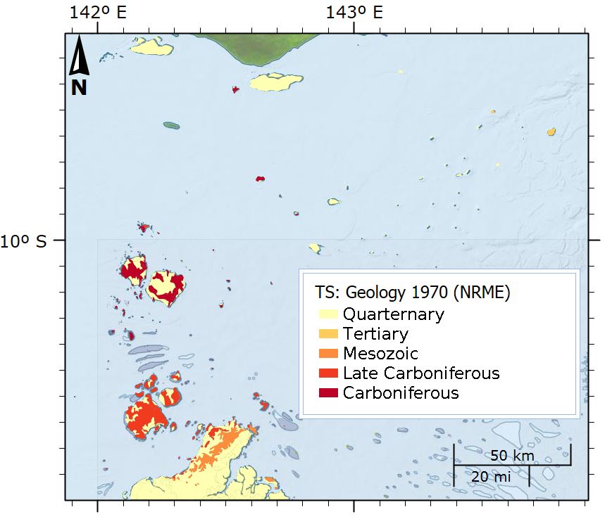
This dataset shows the geology of the Torres Strait region. The polygons in this dataset are a digital representation of the distribution or extent of geological units within the area. Polygons have a range of attributes including unit name, age, lithological description and an abbreviated symbol for use in labelling the polygons. These have been extracted from the Rock Units Table held in the Department of Natural Resources, Mines and Energy Merlin Database. The dataset was compiled in 1970 by WF Willmott (BMR), simplified from mapping in 1968 by DS Trail, WF Willmott, WD Palfreyman (B.M.R), WG Whitaker (G.S.Q.). The islands were mapped using two dinghies operating from a 45-foot chartered launch. Air photography was available for the islands, except for Stephens, Darnley, and Murray Islands, the shapes of which are consequently uncertain. For the Torres Strait Sheet geology was plotted on photoscale maps (1:50,000) made by the Royal Australian Survey Corps, and later reduced to 1:250,000 scale. For the Daru-Maer Island Sheet the geology was plotted directly at 1:250,000 scale. Data Format: Shapefile with 297 polygon features and has a range of attributes including unit name, age, lithological description and an abbreviated symbol for use in labelling the polygons. Definition source: The Rock Units Table held in the Department of Natural Resources, Mines and Energy Merlin Database. ROCK_U_NAM: The Map Unit Name of the polygon. In the case of named units it comprises of the standard binomial name. Unnamed subdivisions of named units include the binomial name with a letter symbol as a suffix. Unnamed units are represented by a letter symbol, usually in combination with a map sheet number. AGE:Geological age of unit (Quarternary, Tertiary, Mesozoic, Late Carboniferous, Carboniferous) LITH_SUMMA: Provides a brief description of the map units as they have been described in the course of the project work, or as has appeared on relevant hard copy map legends. * Basalt lava and tuff * Coastal marine deposits: saltpans, mangrove swamps, lagoonal deposits; sand, mud * Clay, silt, sand, gravel; flood plain alluvium * Leucocratic and porphyritic biotite granite, hornblende-biotite adamellite, granodiorite * Rhyolitic welded tuff, rhyolite, agglomerate, volcanic breccia, andesite, siltstone, arenite * Porphyry * Residual and colluvial soil, sand, gravel, rubble, some semi-consolidated material * Lithics and crystal-rich rhyolitic ignimbrite; volcanic rudite and breccia; rhyolite; andesite; some volcaniclastic sedimentary rocks * Lithics and crystal-rich dacitic to rhyodacitic ignimbrite; tuffaceous siltstone, sandstone * Crystal-rich rhyolitic ignimbrite; rhyolite; volcaniclastic rudite * Sandstone, conglomerate and shale * Younger dune sand and some minor older dune sand with dune ridges ROCK_U_TYP: Provides a means of separating map units, eg for constructing a map reference. This item will contain one of the following: * STRAT- Stratigraphic unit, including sedimentary, volcanic and metamorphic rock units. * INTRU- Intrusive rock units; * COMPST- Compound unit where the polygon includes two or more rock units, either stratigraphic, intrusive or both; * COMPST- Compound unit, as above where the dominant or topmost unit is of the STRAT type; * COMPIN- Compound unit, as above, where the dominant unit is of the INTRU type; * WATER- Water bodies- Large dams, lakes, waterholes. SEQUENCE_N: A numeric field to allow sorting of the rock units in approximate stratigraphic order as they would appear on a map legend. DOMINANT_R: A simplified lithological description to allow generation of thematic maps based on broad rock types. * BASALT * MISCELLANEOUS UNCONSOLIDATED SEDIMENTS * ALLUVIUM * GRANITOID * FELSITES (LAVAS, CLASTICS & HIGH-LEVEL INTRUSIVES) * COLLUVIUM * SEDIMENTARY ROCK * SAND MAP_SYMBOL: Provides an abbreviated label for polygons. Mostly based on the letter symbols as they appear on published maps or the original hard copy compilation sheets. These are not unique across the State, but should be unique within a single map tile, and usually adjacent tiles.
-
This dataset shows the extent of the dugong sanctuary in the Torres Strait which prohibits the taking of dugong (area, gear and method restrictions). The dugong sanctuary is a legislative boundary which is outlined in the Torres Strait Fisheries Management Notice No. 65 http://www.comlaw.gov.au/Details/F2007B00345 . This dataset is for research purposes and is not authoritative. Refer to the legislation for the authoritative definition of the sanctuary.
-
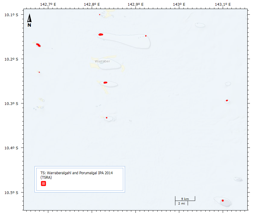
This dataset shows the location and size of the 9 islands, cays and rocks that make up the Warraberalgahl and Porumalgal Indigenous Protected Area (IPA). The IPA is recognised as part of the National Reserve System and was officially declared on the 18/07/2014. The declared area covers approximately 63 hectares. The following Islands, Cays and Rocks make up the IPA: Atub, Bara, Bini, Babui, Guiya, Maza Guiya, Miggi Maituin, Ugain and Ulu. GPS coordinates were used to identify the islands using Google Earth and polygons were manually drawn over this imagery to create the dataset.
-
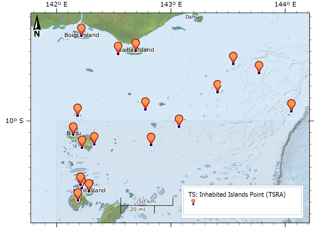
This dataset shows the point location of communities on Torres Strait Islands. There are 18 Islands in the Torres Strait and 19 Communities. St Pauls and Kubin villages are both located on Moa Island. Each point includes an URL attribute pointing to the community pages on the TSRA website. The Island Communities are: Boigu Island, Warraber Island, Ugar Island, Thursday Island, Saibai Island, Poruma Island, Prince of Wales Island, Mer Island, Masig Island, Mabuiag Island, Iama Island, Horn Island, Hammond Island, Erub Island, Dauan Island, Badu Island, St Pauls, Moa Island, Kubin, Moa Island The dataset is a point shapefile, created in ArcGIS Version 10.0. Data Dictionary: - URL: URL to the community page for the island on the TSRA website. - Region: Region within Torres Strait (Northern islands, Central islands, Eastern islands, Southern islands, Western islands) from the Torres Strait Island Regional Council. - Pop2011: Population of each island from the 2011 census. Data Location: This dataset is filed in the eAtlas enduring data repository at: data\TSRA\TS_TSRA_Inhabited-Islands_2014 Change Log: - V2 21-03-2016 (Eric Lawrey, AIMS): Added Regions and population statistics.